Showing posts with label ecology. Show all posts

Monday, May 31, 2021

2021 Field Season Kick Off - week 1

 Kicked off the 2021 field season with a solo trip to State Game Land 91. This unit was cut at least one year ago. My understanding is that this is a shelterwood cut where the canopy is largely removed with just a few standing trees remaining. The unit can be found off Hwy 115 between Wilkes-Barre and Bear Creek. If you want to see Chestnut-sided Warblers or Prairie Warblers this is your spot! This area might had Golden-winged Warblers but I did not detect one (I didn't do any playback for them either). 


This site this interesting because the groundcover strikes me as the understory of a forested site, with ferns (cinnamon and interrupted shown here) and not cover such as grasses, bracken fern, and goldenrods.  


After SGL 91, I took off to the Wilkes Ecology Preserve to do point counts and get trail camera images. Highlights included a young garter snake and a tree swallow that took up the box I put up a few weeks ago. 

young Garter Snake 
Wooly adelgid on hemlock 

Cinnamon Fern

Interrupted Fern 


Dwarf ginsing

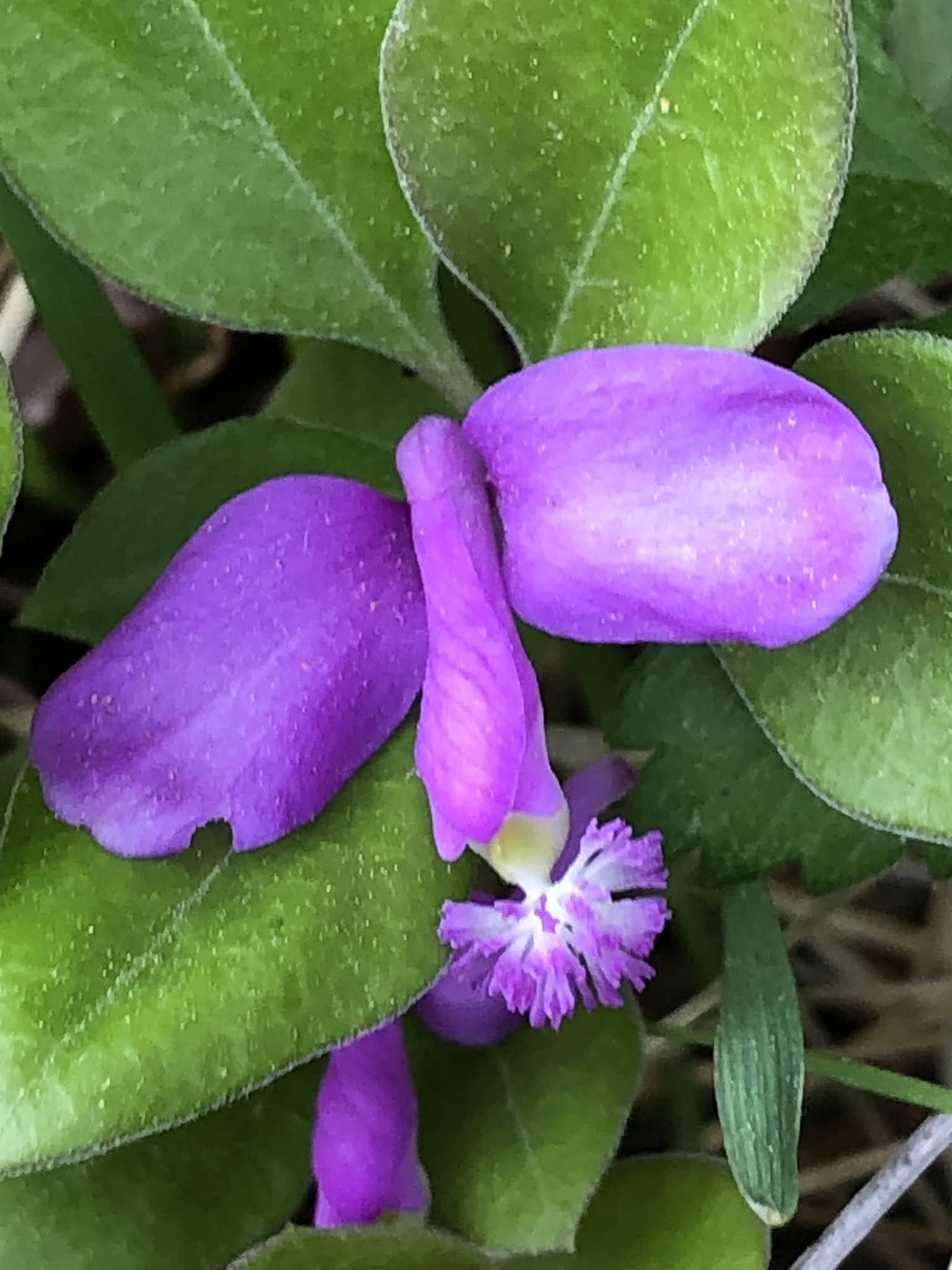
Gaywings 
Red-backed Salamander 


Tupperware containing an Audiomoth unit that was never turned on :\ 
Tree Swallow eggs 

That's it though. One day. A good day. But one day in the field for the whole week. Rain and a hospitalized family member kept me in. Had graduation Sunday and today was Memorial Day. But here's a good week ahead. 

Sunday, May 3, 2020

Tropical Ecology Course Online


Course Description: This course explores ecology and conservation with a focus on tropical forests. 

The textbook: John Kricher's Tropical Ecology

This page: Going to paste links to my lectures, a reading list, and random stuff. Assignments and readings will be through the portal. I'm making this public so anyone can see what is taught in the course. 

Topics 
  • The stage
    • Biomes of the world and their drivers
    • Major habitats within the tropics 
    • Global diversity and history of tropical forests 
  • The players: Tour of tropical diversity 
    • Plants and Forests 
    • Fungi 
    • Invertebrates 
    • Vertebrates 
      • Fish 
      • Amphibians and Reptiles 
      • Mammals 
      • Archosaurs
  • The ecological play 
    • Ecosystem services
    • Nutrient cycling 
    • Disturbances 
    • Predation and coevolution in the tropics
    • Threats to tropical forests 
    • Conservation in the tropics 

Reading list for the tropical ecologist (or enthusiast)

  • Charles Darwin's Voyage of the Beagle - Could be called "Tales of a twenty-year old naturalist" 
  • The Shaman's Apprentice - if you dig ethnobotany, this is a must

Saturday, May 2, 2020

Coffee Course 2020 - Trip to Costa Rica: Foods

I have started co-teaching a course on coffee. This is an interdisciplinary course and the other professor teaches some history of Costa Rica and Latin America as well as the economics of coffee. I teach the biology of coffee but narrowly (e.g., the parts of the coffee cherry = bean + surrounding fruit) and broadly (e.g., tropical climates, soil, photosynthesis). As part of the course, we go to the Tarrazu region of Costa Rica, which is southwest of San Jose. I wanted to make a post about the foods there - all of which were fresh from markets (at least the food we ate). We stopped at a market in Cartago and it was glorious! 

You like beans? We got beans. All kinds! Sold by the kilo. 
Edge of the Cartago market. Every inch of these markets are used. 


Chayote root. Apparently delicious and expensive. This was at a roadside vendor near a chayore farm. I assume chayote is perennial so the vine (not shown) would regrow from the root. Given the fruit (below) are valuable the roots must be even more valuable. So I wonder if the plants has lower production after a number of years and that's when the root can be sacrificed. Question for the next trip. 
Cayote fruits. We ate them in a salad (not shown) but apparently they're very flexible and can be eaten like tomatoes (raw, steamed, fried, pickled, etc) 
   

An edible palm fruit, the pejibaye. This we had buttered and steamed and I loved it. Starchy like yucca. 
Lots of chayote to be found
Fish, chayote, salad, rice, and black beans - standard fare of Costa Rica. No hot sauce is typically used.
I can't remember the name but I think this was in the genus Inga. I believe this to be a large bean pod of a plant in the Fabaceae (bean family). The white part is the edible part and is very sweet. 
This looks like passionfruit but I believe it's just related to it. Grows on a vine (below) and it eaten green (unlike passionfuit, which is yellow) 

Sausage, chicken, nachos = goodness
Cas, very popular in juices. Very tart. 

This and below. No idea. Sweet and delicious. 

Gallos en hoja de platano. This was made special for us by our caterer but this is considered field food. It is a meal by itself: potatoes, beans, sausage, and two corn tortillas that are fitted like a pita. 

Boiled down sugar cane juice and poured them into molds to make a candy. This guy had several acres of coffee and sugar cane that he purchased after working at a diner in New Jersey for four years. I kid you not.
Cashew. Yep. That curly thing at the bottom contains the nut.


Monday, April 27, 2020

Using R to quantify land use around a sampling point

Backstory: I was in Argentina in 2017 for a bird meeting at Iguazu Falls. The meeting was fantastic and I was able to see a bunch of old friends from my tropical days and meet a bunch of new friends and there were many great talks. The two students that went with me did a great job presenting our poster. There were two big downers. One, a student was robbed by a taxi driver in Iguazu. She had to hand over her phone and wallet and he dropped her off along the road in the middle of a national park. Very not cool. Two, in Buenos Aires we were robbed by a taxi when our driver took off with our backpacks as we were removing our luggage. Now I've been taking pictures of taxi drivers and my photos are automatically uploaded. 

We're all told to back up our important documents and that I did. I had code on my hard drive and on a USB drive but both were stolen in the backpack - so I now I have everything on a Google drive and one other place. This will be my third place for this code. 

The problem: So, let's suppose you're doing something ecological at a particular site and you have a bunch of those sites. If you are working in a heterogeneous system you might be interested in the interaction between what is happening at a site and the landscape around the site. Since what constitutes the landscape is nebulous, we can examine the effect of spatial extent on site properties. For example, take the decision of a bird to use a bird house or not. The bird likes trees around the nesting site but does it need to be a forest or just a woodlot? I often refer to larger spatial extents as the context (city, forest, suburban) and smaller spatial extents of local conditions (e.g., a woodlot in a city, a parking lot in the country, and, of course, a woodlot in the woods and a parking lot in the city). So maybe the bird's decision is based on context or local conditions or a combination (much much tougher to sort out since everything in the landscape tends to correlated). 

The general approach: Your ecological points need to geo-referenced in a spreadsheet. To that we will add land use information that we will extract from remote sensing. Then we can run statistics linking the ecological information to the land use. A focal analysis is used where a sampling point serves as the center of a circular buffer. We will count the number of pixels and estimate the proportions of land cover by the relative number of pixels. We will use a 1000 m buffer and a 200 m buffer nested within the large buffer. 

An example of a point (star) where ecological data were collected. The larger circle gives the context of the point (urban) and the smaller circle indicates the local conditions (wood lot).

The land use data set: I use the NLCD 2016 Land Use data from the MRLC website. The map is a raster image (matrix of pixels with numbers representing different land uses). Each pixel is 20 x 20 m pixels so a few km can represent a great deal of data. The image below is roughly, the whole spatial extent that I work. The red banana is the Scranton/Wilkes-Barre greater urban area (aka "The Valley"). To the east is NJ and NY to the northeast. The squiggly line leading to the Scranton/Wilkes-Barre area is the North Branch of the Susquehanna. 
I like examining how ecology changes over a gradient and, unfortunately, the Scranton/Wilkes-Barre area does not really have much of a gradient. The red is high intensity urban and green is forest. You can see that The Valley is intensely urban and the area surrounding the value is very green and beyond that a mix. That ring of green around The Valley is the steep slopes of the surrounding land that is heavily forested (which is nice). To the west and north is farm land (yellow) and to the east and south is a mix of small towns, lakes, and game lands. 

The data are downloaded as a Geo-TIF

The ecology: For this example, I am using predation rates on model clay caterpillars we put on branches to examine predation by birds. When birds bite the clay they leave behind a mark and we consider the caterpillar predated. We put out 20 at a site and those sites are georeferenced with lat and long recorded in degrees decimal (e.g., 72.234). We go back a week later and count to the bite marks to get a predation rate.

And, finally, the code

install.packages("raster", "tmap", "sf", “sp”)

library(raster)
library(sp)
library(sf)
library(tmap)

# the file is NLCD_2016.tiff
landcov <- raster(file.choose()) 
# check it out
plot(landcov)

#get the coordinate reference system to show the spatial info 
crs(landcov)


# get the ecological sampling/clay model data
clay <- read.csv(file.choose(), header=T)

#  turn the points into spatial points and reference them to the location
clay.pts <- st_as_sf(clay, coords=c("long","lat"), crs = 4326)

# look at the coordinate reference system (to make sure the above worked) 
crs(clay.pts)

library(tmap, gstat)
# create a map with the points on top of the map
tm_shape(landcov) + tm_raster() +
  tm_shape(clay.pts) + tm_dots(size = 0.5)

# extract 
landextract2 <- extract(landcov,             # raster layer
  clay.pts,   # SPDF with centroids for buffer
    buffer = 1000,     # buffer size, units depend on CRS
normalizeWeights=TRUE,
    fun=NULL,         # what to value to extract
    df=TRUE)         # return a dataframe? 

# make the output a data frame so I can mess with it as I know how
land <- as.data.frame(landextract2)
# make R count thousands and thousands of pixels for me
a <- table(land$ID, land$NLCD_2016)
write.table(a, "clipboard", sep="\t")

From this run a bunch of models and we can create this graph

Hope this helps someone!! 


Saturday, April 11, 2020

Conservation Biology Online


I've decided to put a large portion of my conservation biology lectures online. They will be slightly less detailed than what I would normally do in class but I will make up for by extra readings. I asked a few of our graduates in graduate school what we were missing and one theme was reading and critiquing the peer-reviewed literature. So that will be part of the course that's for our students but not the public. By what not have public lectures. Maybe I'll get some good feedback. 

As of 4/11 - first two lectures, lecture on threats to tropical forests 

This will be a work in progress.


3. Species and Species Diversity
    
5. Extinctions 


7. Habitat Loss

8. Habitat Fragmentation
    Part 1 and Part 2


11. Invasive Species and Emerging Diseases 

12. Climate Change


14. Threats to Marine Diversity 

15. Global Conservation 

16. Designing Parks 

17. Conservation Law 

18. Habitat Management 

19. Museums, Zoos, Gardens and Freezers

20. Restoration 

21. Funding Conservation 

22. Sustainability  


Sunday, July 12, 2015

Summer Research Week 9

MONDAY 7/6/2015 Nescopeck State Park

The slow down continues with fewer birds vocalizing. Did the powerline easement first and that had Eastern Towhee and Field Sparrows with a single Prairie Warbler. I wouldn't be concerned with these three species in Pennsylvania despite the decreasing numbers - I think they're flexible enough in habitat to take advantage of gas and electric right-aways and I would through in Indigo Buntings as well. I hear these species all summer at my local grocery (Price Chopper) and around the mall as well. 

The fields that are managed for early successional birds had these birds as well and a few more. Goldfinches are becoming more obvious as their breeding season kicks in. Few Chestnut-sided and Yellow Warblers kicking around. Veerys... tons of them, still singing and calling from the edges. I've been seeing more hummingbirds too - maybe drawn to the flowers that are starting to bloom like the butterfly weed below. Blueberries are starting past their peek but bush honeysuckle, an invasive species, is pulling up the slack and they are heavy with fruit. 

Best bird of the day? Large female Cooper's Hawk that I almost hit in the truck 


Blue-gray Gnatcatcher


Butterfly Weed

Wildflower mix

Bush Honeysuckle


TUESDAY 7/6/2015 Beltzville State Park, Jacob's Property

A added a site near the boat launch. Last round, when I finished my survey, the land manager informed me they just sprayed the field. Now this is two weeks later and the site had been mowed (to about 8 inches) and seeded. There were still tons of song sparrows about the scattered shrubs and bluebirds but the yellowthroats were fewer. We'll see how they make out with the next planting.

The primary field didn't have the Eastern Meadowlark that was there last year. That's a species, unlike Field Sparrows, Eastern Towhee, Indigo Buntings, and Prairie Warblers, that we need to intensively manage. So far, I have ZERO meadowlarks and not a single Golden-winged Warbler.

On the upside this site had tons of Bobolinks. 


Jacob's Property, off 115, was really slow. Best bird was a male Sharp-shinned Hawk. There was other cool stuff there. This place needs a bioblitz


WEDNESDAY 7/7/2015 Office 

THURSDAY SGL205 

I didn't go out the day before because of rain. That rain clung to the shoulder-tall grasses. The site consists of several fields and they appear to be managed differently - making for great science. But we only sampled a warm-season and a cool-season grassland. The cool season is full of Red-winged Blackbirds and the edges have all the typical edge species (Indigo Buntings, Eastern Towhee, Field Sparrow). Like the other sites, I had Bobolinks swing by. 


After the survey, I took a ride over to Edge of the Woods Nursery for some native plants. Picked up butterfly weed, bottle gentian, and some irises. Not cheap. While I was there a red fox was working the edge of the fence. 


FRIDAY SGL036

My favorite site and beautiful morning. I didn't get the species I was hoping (Savannah Sparrow, Henslow Sparrow) but I did get the Northern Harrier, Bobolinks flew over, and I picked up a Blue Grosbeak. 


Black-throated Blue Warbler in the woods adjacent to the fields

Good view of the vegetation and a deer waaaay out there


Grasshopper Sparrow - still singing

Northern Harrier cruising the fields


SATURDAY 7/11/2015 Lehigh Gap Nature Center and Kittatinny Ridge 

Gorgeous morning. Birds were few at LGNC as I expect but the Blue Grosbeak was still singing like crazy. After LGNC went up to Kittatinny Ridge where I have my last point on the Appalachian Trail. Life is good.These first two photographs show bare ground at LGNC where heavy metals obliterated the vegetation and soils. 


THAT'S IT FOR POINT COUNTS!